Which iPad models actually have LiDAR
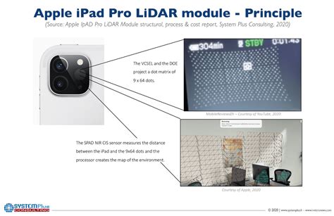
The LiDAR Scanner debuted on the iPad Pro in March 2020, seven months before it reached the iPhone 12 Pro (Apple Newsroom). Every iPad Pro released since has kept it, confirmed as recently as the 12.9-inch 6th generation’s own spec sheet (Apple Support).
| Model | Year | LiDAR Scanner |
|---|---|---|
| iPad Pro 11-inch (2nd gen) / 12.9-inch (4th gen) | 2020 | Yes |
| iPad Pro 11-inch (3rd gen) / 12.9-inch (5th gen) | 2021 | Yes |
| iPad Pro 11-inch (4th gen) / 12.9-inch (6th gen) | 2022 | Yes |
| iPad Pro 11-inch (M4) / 13-inch (M4) | 2024 | Yes |
| iPad, iPad Air, iPad mini (any generation) | — | No |
The table settles the most common confusion in this space directly: LiDAR has never appeared on a non-Pro iPad, at any price point or generation. To confirm your own model number, check Settings, then General, then About (Apple Support).
Does the base iPad or iPad Air have LiDAR?No. Apple has only ever built the sensor into the iPad Pro line, starting with the 2020 models. An iPad Air or standard iPad cannot add it through software.
Pick your scan type before you pick an app
The three scanning jobs need different apps and different physical technique, and treating them as one activity is where most quick guides go wrong. KIRI Engine’s own LiDAR feature, for instance, splits its tool into three separate modes for exactly this reason (KIRI Engine).
| Goal | App category | Technique | Common failure |
|---|---|---|---|
| Single object (product, part, small item) | Object-capture apps (Polycam, 3D Scanner App) | Keep the iPad roughly 0.3 to 1 meter from the object, circle it slowly at a constant distance | Shiny, dark, or very thin parts drop out of the mesh |
| One room | Room-scan apps (SiteScape, Metaroom, Canvas) | Walk the perimeter once, sweeping floor to ceiling, staying inside the 5-meter range | Moving too fast causes tracking loss mid-wall |
| Multiple rooms or a whole floor | Multi-room-capable apps (SiteScape, Metaroom) | Scan one room at a time and let the app stitch them together | Hitting the app’s free-tier area limit partway through |
The three paths share almost nothing procedurally: an object scan wants you close and circling, a room scan wants you walking a perimeter at range, and a multi-room scan is really several room scans stitched together instead of one continuous sweep.
Scanning a single object, step by step
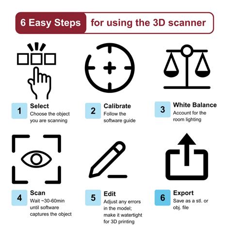
For a quick measurement rather than a full 3D model, Apple’s built-in Measure app already uses the LiDAR sensor once it’s installed. Open Measure, point the circle at one end of the object, wait for the yellow guide line to lock onto the edge, then drag to the other end to read the measurement, and tap the shutter button to save a screenshot of it.
For an exportable 3D model, an object-capture app takes over from Measure. The workflow is the same across these apps: start a new capture, hold the iPad about arm’s length from the object, and circle it slowly in one continuous pass, keeping the object centered and flipping it mid-scan if the app supports capturing the underside.
Do I need an internet connection to scan?No. The scan itself, both depth capture and mesh building, happens on-device. A connection is only needed to upload, share, or sync the result afterward, and even that step is optional in most of these apps.
Scanning a room, step by step
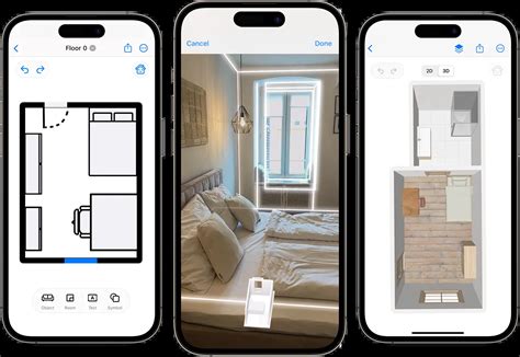
Start the room-scan mode in your chosen app, stand near the center of the space, and begin recording. Sweep the iPad across walls, floor, and ceiling at a steady walking pace, staying within roughly 5 meters of every surface you want captured, since that is the sensor’s stated operating range (Next Reality, quoting Apple). Close doors and open curtains or blinds before you start; it reduces the number of surfaces the app has to reconcile mid-scan. Finish by returning to roughly where you started, then stop the recording.
Scanning more than one room

A single free scan in SiteScape captures up to about 2,000 square feet, or roughly 7 million points, before you hit the app’s free-tier ceiling (SiteScape). Metaroom’s multi-room mode caps each individual scan at 10 by 10 meters, and merges separate scans into one combined model afterward; its paid Workspace tier for processing and export starts at €12.49 per month (Metaroom). In practice, a whole-apartment capture is rarely one continuous sweep. It’s several room-sized scans, stitched together by the app after the fact.
Why your scan comes out wrong
| Symptom | Likely cause | Fix |
|---|---|---|
| Holes or missing patches in the mesh | Reflective or very dark surface, or the surface was outside the 5-meter range | Rescan that patch closer, or from a different angle |
| Blurry or smeared texture, geometry fine | Low ambient light hurting the RGB camera, not the depth sensor itself | Turn on more lights; depth capture works in the dark, texture quality does not |
| Scan freezes or “tracking lost” mid-sweep | Moved too fast, or pointed at a large blank wall with no visual features to track against | Slow down, and briefly pan toward furniture or a doorway to help the tracker re-anchor |
| Whole room measures slightly off from a tape measure | Normal for this sensor class; independent testing found roughly ±3 cm horizontal and ±7 mm vertical accuracy in one controlled study | Treat the scan as good enough for layout and estimating, not a substitute for a certified survey |
| Thin objects (chair legs, wires, railings) missing entirely | LiDAR’s point density can’t resolve features much narrower than about a centimeter at typical scanning distance | Scan those elements separately at very close range, or add them manually afterward |
The accuracy figure in that fourth row comes from a controlled, published comparison (ScienceDirect), not a marketing claim, and it settles a specific question: a LiDAR scan is precise enough to plan a renovation or order flooring, not precise enough to replace a certified land survey.
Will LiDAR scanning work outdoors?Apple states the sensor works both indoors and outdoors, but direct sunlight can wash out the infrared return signal the LiDAR relies on, which is why most guidance and testing on this sensor focuses on indoor use.
What happens to the file afterward
| Goal | Format you need | Apps that provide it |
|---|---|---|
| View or share a quick 3D preview | GLTF or a web viewer link | Polycam’s free tier exports GLTF only (SkyeBrowse review) |
| Import into Blender, or 3D-print the model | OBJ, STL, or PLY | Polycam (paid tiers only), 3D Scanner App |
| Import a floor plan into CAD or BIM software | DXF or IFC | Metaroom (Amrax), or export directly to Revit, AutoCAD, ArchiCAD, SketchUp, Navisworks, or Revizto from SiteScape |
| Georeferenced export for GIS work | GeoTIFF or georeferenced LAS | Requires a Business-tier plan in apps like Polycam |
The practical rule holds across every app in this category: the free tier is a preview mechanism, and any format you’d actually use downstream, whether that’s 3D printing, CAD import, or GIS work, is a paid feature.
Can I turn a room scan into a CAD file?Yes, through apps built for that specifically. SiteScape and Metaroom both export directly to CAD- and BIM-compatible formats; a general-purpose object scanner like Polycam or 3D Scanner App isn’t built for that workflow.
iPad or iPhone for this
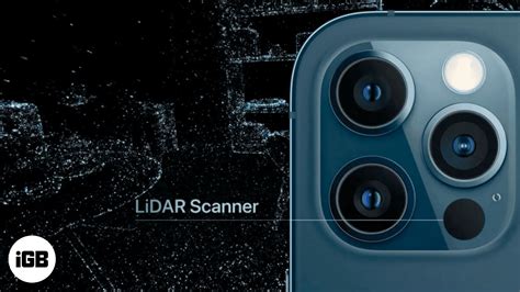
Both platforms use the same LiDAR hardware generation and the same 5-meter range once a device has the sensor at all. An iPad’s larger screen makes it noticeably easier to watch the live mesh fill in while scanning a room, which matters most for spotting missed patches before you finish. An iPhone stays more practical for scanning while awkwardly angled, like reaching over furniture, since it’s easier to hold one-handed in a tight space.
How accurate is this, really
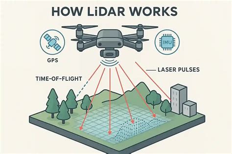
That gap between marketing language and measured results doesn’t make the sensor unreliable for what most people actually use it for: knowing whether a sofa fits, roughing out a floor plan, or documenting a space before a renovation.
Is a 3-year-old iPad Pro still good enough for this?Yes. Apple hasn’t changed the LiDAR Scanner’s fundamental range or resolution since its 2020 introduction; every iPad Pro since has carried the same class of sensor, so an older Pro model scans just as capably as a current one.